


Dmitry Lysov is a first-year Master's student at the Faculty of Chemical, Biological, and Geographical Sciences at Vitebsk State University named after P.M. Masherov and a Specialist at the republican unitary enterprise GEOSERVICE. His research focus is on the reuse of fill soils in construction. This involves studying soil compaction and self-compaction, as well as comparing strength and deformation parameters in this process.
– Let's say there's a gully or vacant lot that's mapped in the general development layout, and in 10-20 years, they'll start building something there. Until then, they just fill it up without any control. Before starting to develop the territory, these volumes of soil have to be removed, which is itself costly, and the site has to be prepared again. But if it is initially filled following a specific procedure and with an understanding of the parameters, then this territory may easily be suitable for construction, including for 2-5-story buildings, without removing soil, - explained the master’s student.
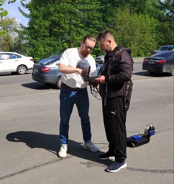
At KarRC RAS, Dmitry Lysov went through practical training in geophysics under the guidance of Pavel Ryazantsev, Leading Researcher at the Institute of Geology KarRC RAS. The scientists focused primarily on the use of ground-penetrating radar (GPR) and electrical resistivity tomography (ERT) methods using the Omega-48 instrument system and various software programs.
– GPR is used quite widely in Belarus, particularly in the inspection of building structures. But this is the first time I see 2D and 3D electrical resistivity imaging—it's an interesting and efficient technique, – noted Dmitry Lysov.
He explained that in construction, particularly in the gas and petrochemical industries, it is necessary to determine the soil's specific resistivity in order to calculate for grounding. Liquids in pipelines create a current that causes metal corrosion. To minimize the damage — to reduce the corrosion of metal structures and pipes — it is important to understand the electrical conductivity of the soil. Nowadays, it is determined by the vertical electrical sounding (VES) method, and usually three people are involved in this work.
– The 3D electrical resistivity imaging system is much better: its output is more accurate, the processing quality is higher, and the labor and time costs are three times lower. It can be handled by one person. In addition, 3D models can quite clearly image soil anomalies and defects in structures. We rarely use it, but it is worth adopting, - said Dmitry Lysov, evaluating the results of the internship.
During his trip, the guest from Vitebsk had time to see Petrozavodsk and visit some sights in the Prionezhsky and Kondopozhsky districts of the republic, including the Girvas paleovolcano and the Kivach waterfalls. In the city, Dmitry Lysov was particularly impressed by the Onego lakefront and the outdoor gym installed along the shore.
As a reminder, there is a cooperation agreement between the Karelian Research Center RAS and the Vitebsk State University. One of the cooperation formats is participation of students, doctoral students, and young scientists in events organized by the parties.
KarRC RAS
in social media


in social media
News
June 6, 2025
Study trip to KarRC RAS helps specialist from Vitebsk master new electrical resistivity imaging techniques, with applications in construction
Cooperation of Karelian Research Center RAS with Vitebsk State University continues. On June 5, the University's Master's student Dmitry Lysov completed his practical training course. The construction industry specialist studied the geophysical methods used by researchers at KarRC RAS.
Cooperation of Karelian Research Center RAS with Vitebsk State University continues. On June 5, the University's Master's student Dmitry Lysov completed his practical training course. The construction industry specialist studied the geophysical methods used by researchers at KarRC RAS.
See also:
September 11, 2025
Scientists performing integrated monitoring of Ladoga Skerries NP ecosystems
A multidisciplinary expedition to the Ladoga Skerries National Park was performed by specialists from several subdivisions of KarRC RAS. The focus was on the park’s plants and animals. Scientists map the forest cover and its dynamics, identify rare species, and evaluate human impact on the natural ecosystems. The results can be used when planning economic and recreational activities in the protected area.
A multidisciplinary expedition to the Ladoga Skerries National Park was performed by specialists from several subdivisions of KarRC RAS. The focus was on the park’s plants and animals. Scientists map the forest cover and its dynamics, identify rare species, and evaluate human impact on the natural ecosystems. The results can be used when planning economic and recreational activities in the protected area.

September 10, 2025
Karelian scientists performed an expedition in the footsteps of Elias Lönnrot and Into Kondrad Inha
Staff of the Institute of Linguistics, Literature and History KarRC RAS went on an expedition around northern parts of Karelia, visiting places journeyed in the 19th century by collector of Karelian runo songs and author of the “Kalevala” epic Elias Lönnrot and by a well-known Finnish journalist and photographer Into Kondrad Inha.
Staff of the Institute of Linguistics, Literature and History KarRC RAS went on an expedition around northern parts of Karelia, visiting places journeyed in the 19th century by collector of Karelian runo songs and author of the “Kalevala” epic Elias Lönnrot and by a well-known Finnish journalist and photographer Into Kondrad Inha.